The Grand Canyon stands as a testament to the Earth’s dynamic geological history, offering a breathtaking glimpse into nearly two billion years of our planet’s past. This iconic landmark, carved by the relentless flow of the Colorado River, reveals a mesmerising tapestry of rock layers that tell the story of ancient seas, shifting continents, and dramatic climate changes. As you gaze upon its vast expanse, you’re witnessing a geological masterpiece that continues to evolve before our eyes.
Stratigraphy of the grand canyon: unraveling 2 billion years of earth’s history
The Grand Canyon’s stratigraphy is a veritable time machine, allowing geologists and visitors alike to journey through eons of Earth’s history. Each layer of rock represents a distinct chapter in the planet’s geological narrative, with the oldest rocks at the bottom dating back nearly two billion years. This remarkable sequence of sedimentary, igneous, and metamorphic rocks provides an unparalleled record of environmental and tectonic changes that have shaped North America.
As you descend into the canyon, you’re essentially travelling backwards in time. The topmost layers, such as the Kaibab Formation, were deposited around 270 million years ago in a shallow marine environment. Deeper layers reveal ancient sand dunes, tropical seas, and even evidence of primitive life forms . The diversity of rock types and formations within the Grand Canyon offers a unique opportunity to study the complex interplay of geological processes over an enormous span of time.
Geological formations and rock types in the grand canyon
The Grand Canyon’s rock formations are a geologist’s dream, showcasing a wide array of rock types and structures that provide insights into the Earth’s past environments and tectonic activity. From the ancient metamorphic basement to the more recent sedimentary layers, each formation tells a unique story of deposition, transformation, and erosion.
Vishnu basement rocks: the ancient metamorphic foundation
At the very bottom of the Grand Canyon lie the Vishnu Basement Rocks, some of the oldest exposed rocks in North America. These metamorphic rocks, primarily schists and gneisses, formed under intense heat and pressure nearly two billion years ago. The Vishnu Basement represents a period of mountain-building and continental collision, providing a glimpse into the Earth’s early crustal processes.
Grand canyon supergroup: tilted layers of proterozoic sedimentary rocks
Above the Vishnu Basement lies the Grand Canyon Supergroup, a series of tilted sedimentary and volcanic rocks deposited between 1.2 billion and 740 million years ago. These rocks, including the vibrant red Hakatai Shale and the dark Cardenas Basalt, record a time of rifting and basin formation . The tilted nature of these layers indicates significant tectonic activity before the deposition of overlying horizontal strata.
Tapeats sandstone: the great unconformity’s marker
The Tapeats Sandstone marks a significant gap in the geological record known as the Great Unconformity. This layer, deposited around 525 million years ago, rests directly on much older rocks, representing a time gap of over a billion years. The Tapeats Sandstone is evidence of a marine transgression, where ancient seas flooded the continent, depositing sand and gravel over an eroded landscape.
Bright angel shale and muav limestone: cambrian marine deposits
Above the Tapeats Sandstone lie the Bright Angel Shale and Muav Limestone, both deposited during the Cambrian Period. These formations represent a continued marine environment, with the shale indicating deeper, quieter waters and the limestone suggesting shallower seas teeming with early marine life. Fossils found in these layers provide crucial information about the evolution of early complex organisms.
Redwall limestone: the massive mississippian Cliff-Former
The Redwall Limestone is one of the most prominent features in the Grand Canyon, forming massive, sheer cliffs that can be seen for miles. Deposited during the Mississippian Period, about 340 million years ago, this thick limestone layer represents a time when a warm, shallow sea covered much of North America. The distinctive red colour of the Redwall is actually due to iron oxide staining from overlying red beds, rather than the limestone itself .
Tectonic forces and structural geology of the grand canyon
The Grand Canyon’s formation is not solely the result of erosion; tectonic forces have played a crucial role in shaping its structure and topography. Understanding the tectonic history of the region is essential for comprehending the canyon’s current form and ongoing geological processes.
Colorado plateau uplift: shaping the canyon’s vertical profile
The uplift of the Colorado Plateau, which began around 70 million years ago, is a key factor in the Grand Canyon’s formation. This regional uplift raised the entire area by several thousand feet, providing the necessary elevation difference for the Colorado River to carve the canyon. The uplift occurred in several phases, with the most recent significant episode taking place in the last 5-6 million years.
The mechanism behind this uplift is still debated among geologists. Some theories suggest it’s related to changes in the underlying mantle, while others propose crustal thickening due to plate tectonic interactions. Regardless of the exact cause, the uplift of the Colorado Plateau set the stage for the dramatic erosion that would eventually reveal the Grand Canyon’s spectacular rock layers .
Kaibab and coconino plateau: influence on canyon morphology
The Kaibab and Coconino Plateaus, which form the rims of the Grand Canyon, have significantly influenced its morphology. These high, flat surfaces are composed of resistant limestone and sandstone layers that have withstood erosion better than the underlying softer rocks. The differential erosion between these resistant cap rocks and the softer layers beneath has contributed to the canyon’s distinctive stepped profile.
The plateaus also affect the canyon’s width and the development of side canyons. Areas where the resistant Kaibab Formation has been breached tend to have wider, more open canyon profiles, while sections where it remains intact often have narrower, steeper walls.
Fault systems: grand wash, hurricane, and toroweap faults
Several major fault systems cut across the Grand Canyon region, influencing its structure and topography. The Grand Wash, Hurricane, and Toroweap faults are particularly significant. These normal faults, which formed as a result of extensional forces in the Earth’s crust, have created dramatic offsets in the rock layers, sometimes exceeding 1,000 feet.
The faults not only affect the canyon’s geometry but also play a role in groundwater movement and the formation of springs. Understanding these fault systems is crucial for assessing geological hazards in the region, including the potential for earthquakes and landslides.
Erosional processes and landscape evolution in the grand canyon
While tectonic forces set the stage, it’s the relentless power of erosion that has sculpted the Grand Canyon into its awe-inspiring form. Various erosional processes, working in concert over millions of years, continue to shape this dynamic landscape.
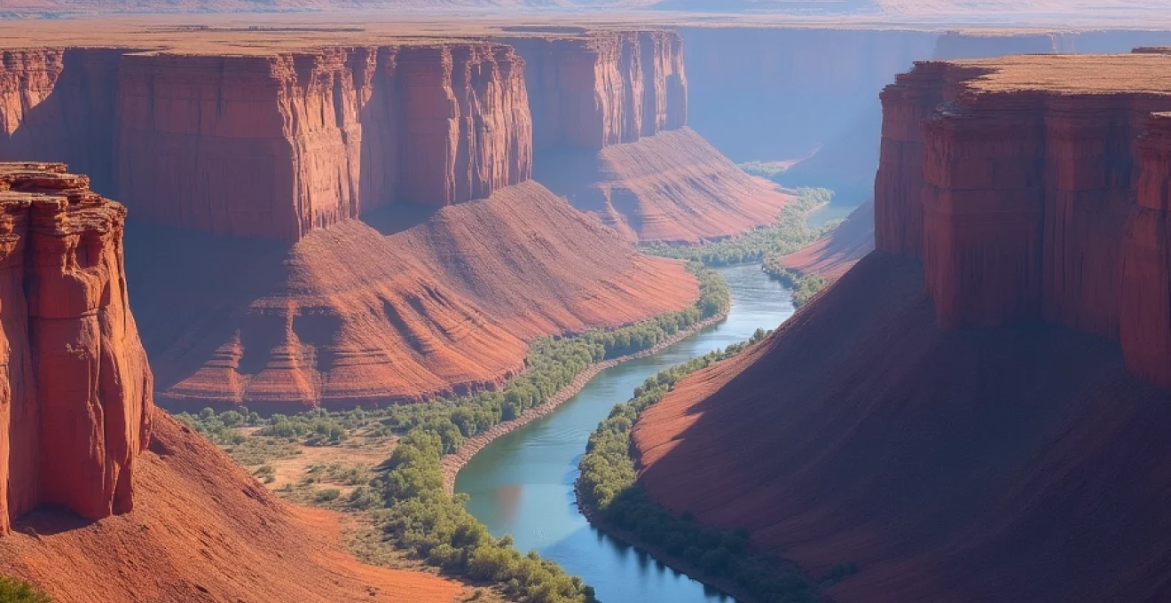
Colorado river’s role in carving the canyon
The Colorado River is the primary architect of the Grand Canyon, carving through layer after layer of rock over the past 5-6 million years. The river’s erosive power comes from its volume, gradient, and sediment load. During periods of flooding, the river can carry enormous boulders, which act like natural sandpaper, scouring the riverbed and canyon walls.
The river’s downcutting action has been remarkably rapid in geological terms, sometimes eroding at rates of up to 1 foot per thousand years . This rapid erosion is partly due to the Colorado Plateau’s uplift, which steepened the river’s gradient and increased its erosive potential.
Differential erosion: shaping buttes, mesas, and temples
Differential erosion, where softer rocks erode more quickly than harder ones, is responsible for many of the Grand Canyon’s iconic landforms. This process creates the stepped appearance of the canyon walls, with resistant layers forming cliffs and softer layers creating slopes. Over time, as erosion continues, isolated buttes, mesas, and temples are left standing as testaments to the canyon’s former extent.
The interplay between differential erosion and the canyon’s complex stratigraphy has resulted in a landscape of incredible diversity and beauty. Features like the Temple of Isis or Zoroaster Temple showcase how differential erosion can create stunning natural sculptures from the canyon’s varied rock layers.
Kaibab formation: the canyon’s resistant caprock
The Kaibab Formation, which forms the rim of the Grand Canyon in many areas, plays a crucial role in the canyon’s erosional history and current morphology. This resistant limestone layer acts as a protective caprock, slowing the rate of erosion and helping to maintain the canyon’s steep walls.
As the Colorado River and its tributaries cut through the Kaibab Formation, they encounter less resistant layers beneath, leading to more rapid erosion and canyon widening. This process creates the distinctive profile of the Grand Canyon, with its wide upper sections and narrower lower gorge.
Paleoenvironmental reconstructions from grand canyon sediments
The diverse sedimentary rocks of the Grand Canyon provide a wealth of information about past environments and climates. By studying the composition, texture, and fossil content of these rocks, geologists can reconstruct ancient landscapes and ecosystems that existed millions of years ago.
Coconino sandstone: evidence of ancient desert environments
The Coconino Sandstone, deposited about 275 million years ago, is a striking example of an ancient desert environment preserved in the Grand Canyon’s walls. This formation consists of light-coloured, cross-bedded sandstone that was once part of a vast sand dune field covering much of the southwestern United States.
The large-scale cross-bedding in the Coconino Sandstone provides evidence of wind direction and dune migration patterns in this ancient desert . Fossil trackways found in this formation offer insights into the types of animals that inhabited this harsh environment, including early reptiles and amphibians.
Hermit formation: indicators of pennsylvanian swamp ecosystems
The Hermit Formation, which lies beneath the Coconino Sandstone, represents a dramatically different environment. Deposited during the Pennsylvanian Period, about 300 million years ago, this formation consists of red shales and siltstones that indicate a humid, tropical climate with extensive swamps and floodplains.
Fossil plant remains found in the Hermit Formation, including ferns, seed ferns, and early conifers, provide valuable information about the vegetation that thrived in these ancient wetlands. These fossils not only help in reconstructing the ecosystem but also contribute to our understanding of plant evolution during this critical period in Earth’s history.
Supai group: cyclic deposition in shallow seas and coastal plains
The Supai Group, a thick sequence of red sandstones and shales, records a complex history of environmental changes during the Pennsylvanian and early Permian periods. These rocks show evidence of cyclical changes between shallow marine, coastal, and terrestrial environments.
The alternating layers within the Supai Group reflect sea-level fluctuations and changes in sediment supply. Studying these cycles helps geologists understand ancient climate patterns and global sea-level changes. The presence of marine fossils in some layers and terrestrial plant remains in others further supports the interpretation of these shifting environments.
Modern geohazards and geological processes in the grand canyon
While the Grand Canyon’s formation spans millions of years, it remains a dynamic landscape subject to ongoing geological processes and potential hazards. Understanding these modern processes is crucial for managing the park and ensuring visitor safety.
Rock falls and landslides: ongoing canyon wall erosion
Rock falls and landslides are among the most visible and dramatic ongoing geological processes in the Grand Canyon. These events, ranging from small rockfalls to massive landslides, continue to shape the canyon’s walls and contribute to its widening. Factors such as freeze-thaw cycles, rainfall, and seismic activity can trigger these events.
Recent studies have shown that rock falls occur more frequently than previously thought, with an average of one significant event every few weeks . While most are small and go unnoticed, larger events can pose significant hazards to hikers and rafters. Park managers closely monitor unstable areas and may close trails or campsites when necessary to ensure visitor safety.
Flash floods: impacts on side canyons and tributary systems
Flash floods are a significant geohazard in the Grand Canyon, particularly in narrow side canyons and tributary systems. These sudden, powerful floods can occur during intense rainstorms, especially during the summer monsoon season. The steep terrain and lack of soil cover in many areas of the canyon contribute to rapid runoff and the formation of dangerous flash floods.
These floods not only pose risks to visitors but also play a crucial role in shaping the canyon’s landscape. They transport large amounts of sediment, carve new channels, and contribute to the erosion of the canyon walls. Understanding flash flood dynamics is essential for both safety planning and studying the canyon’s ongoing geomorphological evolution.
Seismic activity: monitoring the canyon’s geological stability
While the Grand Canyon region is not known for frequent large earthquakes, seismic activity does occur and plays a role in the area’s geological processes. The major fault systems that cross the canyon, such as the Bright Angel Fault, have the potential to generate significant earthquakes.
Seismic monitoring in and around the Grand Canyon helps geologists understand the region’s tectonic activity and assess potential risks. This monitoring is crucial not only for public safety but also for studying how seismic events might trigger other geological processes, such as landslides or changes in groundwater flow.
The Grand Canyon continues to be a living laboratory for geologists, offering new insights into Earth’s history and ongoing geological processes. As research techniques advance, our understanding of this magnificent landscape deepens, revealing the complex interplay of forces that have shaped and continue to shape one of the world’s most iconic geological wonders.