Guatemala’s dramatic landscape is dominated by a chain of towering volcanoes, offering intrepid travellers the chance to witness nature’s raw power up close. These geological giants, forged by the collision of tectonic plates, have shaped the country’s history, culture, and ecology. From the fiery lava flows of Pacaya to the twin peaks of Acatenango and Fuego, and the serene slopes of San Pedro overlooking Lake Atitlán, volcano trekking in Guatemala promises an unforgettable adventure at the edge of fire.
Geological formations of guatemala’s volcanic arc
Guatemala’s volcanic landscape is part of the Central American Volcanic Arc, a segment of the Pacific Ring of Fire. This arc stretches over 1,500 kilometres from Mexico to Panama, formed by the subduction of the Cocos Plate beneath the Caribbean Plate. The result is a string of over 30 volcanoes in Guatemala alone, with many still active today.
The volcanoes in Guatemala are primarily stratovolcanoes, characterised by their steep, conical shapes built up by layers of hardened lava, ash, and rock. These formations are the product of countless eruptions over millions of years, each adding new layers to the volcano’s structure. The composition of these layers varies, reflecting changes in magma chemistry and eruption styles over time.
One of the most fascinating aspects of Guatemala’s volcanic arc is its diversity. Some volcanoes, like Pacaya, are known for their frequent, relatively mild eruptions, while others, such as Fuego, are capable of more explosive activity. This variety is due to differences in magma composition, gas content, and the internal plumbing systems of each volcano.
Pacaya: guatemala’s most active stratovolcano
Pacaya, located just 30 kilometres southwest of Guatemala City, is one of the country’s most accessible and frequently visited volcanoes. Standing at 2,552 meters (8,373 feet) above sea level, Pacaya has been in an almost constant state of eruption since 1965, making it a prime destination for volcano enthusiasts and researchers alike.
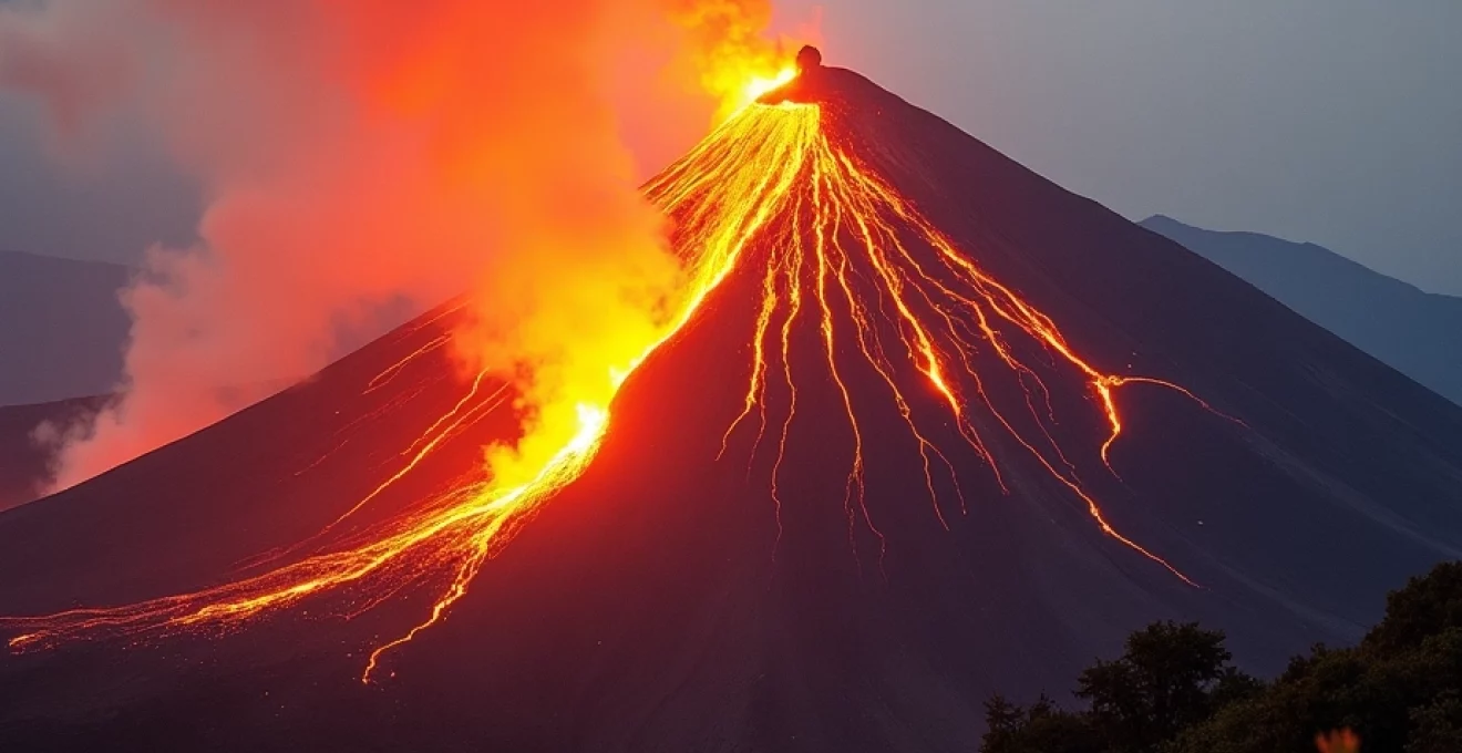
Lava dome formation and strombolian eruptions
Pacaya’s eruptive activity is characterised by its Strombolian eruptions , named after the volcano Stromboli in Italy. These eruptions typically involve rhythmic explosions that eject lava fragments, ash, and gases into the air. The volcano’s summit often features a lava dome, a mound-like structure formed by the accumulation of viscous lava.
The lava dome at Pacaya’s summit is a dynamic feature, constantly changing shape and size. During periods of increased activity, the dome may grow rapidly, sometimes collapsing to form pyroclastic flows. These fast-moving currents of hot gas and volcanic matter can be extremely dangerous, necessitating careful monitoring and sometimes evacuation of nearby communities.
Pyroclastic flow hazards in santa catarina pinula
The town of Santa Catarina Pinula, located on the slopes of Pacaya, has experienced the devastating effects of pyroclastic flows firsthand. In 2010, a particularly violent eruption sent ash and debris raining down on the town, forcing thousands to evacuate. This event underscored the importance of robust hazard monitoring and evacuation protocols in volcanic regions.
Despite the risks, the local communities have developed a deep connection with Pacaya. Many residents work as guides, leading tourists up the volcano’s slopes. This economic dependence on volcanic tourism creates a complex relationship between the communities and the ever-present threat of eruption.
Night ascents and marshmallow roasting on active vents
One of the most popular activities at Pacaya is the night ascent to view the glowing lava flows. Trekkers set out in the late afternoon, timing their arrival at the summit to coincide with sunset. As darkness falls, the volcano’s fiery nature is revealed, with streams of molten rock visible against the night sky.
A quirky tradition has developed among visitors to Pacaya: roasting marshmallows over the volcano’s hot vents. While this might seem like a lighthearted activity, it serves as a tangible demonstration of the intense heat emanating from the volcano’s core. However, visitors should always follow guide instructions and safety protocols, as conditions can change rapidly on an active volcano.
Acatenango and fuego: twin peaks of fire
The volcanoes Acatenango and Fuego form an impressive duo, standing side by side in the Guatemalan highlands. Acatenango, at 3,976 meters (13,045 feet), is the third-highest peak in Central America, while Fuego, slightly shorter at 3,763 meters (12,346 feet), is one of the most active volcanoes in the world.
Fuego’s plinian eruptions and ash plumes
Fuego, aptly named “Volcano of Fire” in Spanish, is renowned for its frequent and often spectacular eruptions. The volcano’s activity ranges from small, almost constant emissions of ash and steam to larger, more explosive events known as Plinian eruptions .
Plinian eruptions, named after Pliny the Younger who described the eruption of Vesuvius in 79 AD, are characterised by their violence and the enormous ash plumes they produce. These plumes can reach heights of tens of kilometres, spreading ash over vast areas and sometimes causing disruptions to air travel.
In June 2018, Fuego experienced its largest eruption in recent history, producing pyroclastic flows that devastated nearby communities and claimed hundreds of lives. This tragic event served as a stark reminder of the power and unpredictability of volcanic activity.
Acatenango’s alpine ecosystems and cloud forests
While Fuego steals the show with its fiery displays, Acatenango offers a different kind of volcanic experience. The trek up Acatenango takes hikers through a variety of ecosystems, from farmland at the base to alpine environments near the summit. One of the most striking features is the cloud forest that cloaks the volcano’s middle elevations.
These cloud forests are home to a diverse array of plant and animal species, many of which are endemic to the region. As trekkers ascend, they may encounter colorful quetzals, Guatemala’s national bird, or spot tracks of elusive mammals like the margay, a small wild cat.
Overnight camping at acatenango’s summit
One of the most memorable experiences for volcano trekkers in Guatemala is camping overnight on Acatenango’s slopes. From this vantage point, hikers have a front-row seat to Fuego’s pyrotechnic displays. As night falls, the glowing lava becomes visible, punctuated by explosive bursts that light up the sky.
Camping on Acatenango requires proper preparation and equipment. The high altitude means temperatures can drop below freezing at night, and winds can be strong. However, for those willing to brave the elements, the reward is an unparalleled view of one of nature’s most awe-inspiring spectacles.
Seismic monitoring and eruption forecasting
The proximity of Acatenango and Fuego to populated areas necessitates constant monitoring. The Instituto Nacional de Sismología, Vulcanología, Meteorología e Hidrología (INSIVUMEH) maintains a network of seismometers and other instruments to track volcanic activity.
Scientists use a combination of seismic data, gas emissions, ground deformation measurements, and thermal imaging to assess the state of the volcanoes and forecast potential eruptions. This information is crucial for issuing timely warnings to local communities and managing tourist access to the volcanoes.
San pedro: lake atitlán’s volcanic guardian
San Pedro volcano, rising 3,020 meters (9,908 feet) above sea level, stands sentinel over the stunning Lake Atitlán. Unlike its more volatile cousins Pacaya and Fuego, San Pedro has been dormant for thousands of years, allowing for a more relaxed trekking experience.
The hike up San Pedro offers a blend of natural beauty and cultural immersion. The trail passes through coffee plantations and cornfields tended by local Maya farmers before ascending into lush cloud forests. The summit provides panoramic views of Lake Atitlán and its surrounding volcanoes, a sight that has inspired artists and travelers for centuries.
San Pedro’s slopes are home to several Maya communities, each with its own distinct traditions and textiles. Trekkers have the opportunity to learn about local customs and the deep spiritual connection the Maya people have with the volcanic landscape.
Trekking logistics and safety protocols
Volcano trekking in Guatemala requires careful planning and adherence to safety guidelines. While the allure of these fiery giants is undeniable, it’s crucial to approach them with respect and caution.
Inguat-certified guide requirements
The Guatemalan Tourism Institute (INGUAT) requires that all volcano treks be led by certified guides. These guides undergo rigorous training in safety procedures, first aid, and environmental conservation. They also possess in-depth knowledge of the volcanoes’ geology, ecology, and cultural significance.
When booking a volcano trek, always verify that your guide is INGUAT-certified. This ensures not only your safety but also supports sustainable tourism practices that benefit local communities.
Altitude acclimatization strategies
Many of Guatemala’s volcanoes reach altitudes where altitude sickness can be a concern. Proper acclimatization is essential, especially for treks to higher peaks like Acatenango. Some strategies for acclimatization include:
- Ascending gradually, with overnight stops at intermediate altitudes
- Staying well-hydrated and avoiding alcohol
- Taking rest days to allow your body to adjust
- Considering medication like acetazolamide under medical advice
It’s important to listen to your body and descend if you experience severe symptoms of altitude sickness. Your guide should be trained to recognize and respond to altitude-related issues.
Emergency evacuation plans and CONRED alerts
The National Coordinator for Disaster Reduction (CONRED) in Guatemala is responsible for issuing alerts and coordinating emergency responses in case of volcanic activity. Trekking companies are required to have emergency evacuation plans in place and to stay informed about current alert levels.
Before embarking on a volcano trek, familiarize yourself with the evacuation procedures and ensure you have appropriate insurance coverage. It’s also wise to register with your embassy or consulate when traveling in volcanic regions.
Cultural significance of volcanoes in mayan cosmology
In Mayan cosmology, volcanoes hold profound spiritual significance. They are often seen as dwelling places of gods and portals between the earthly realm and the underworld. The Maya people have long incorporated volcanoes into their rituals and oral traditions.
One example is the belief that the gods use volcanoes as celestial kitchens, with eruptions representing the cooking of divine meals. This concept is reflected in the Maya calendar, where certain days are associated with volcanic activity and its spiritual implications.
Many Maya communities continue to perform ceremonies at volcanic sites, asking for blessings or protection from eruptions. These rituals often involve offerings of food, flowers, and copal incense, creating a mesmerizing blend of ancient tradition and natural wonder.
For trekkers, understanding the cultural context of Guatemala’s volcanoes adds depth to the experience. It’s a reminder that these geological formations are not just natural phenomena but also integral parts of living cultural landscapes.
As you stand atop one of Guatemala’s majestic volcanoes, gazing out over a landscape shaped by fire and time, you’re not just witnessing a geological marvel. You’re participating in a tradition of wonder and respect that stretches back thousands of years, connecting the present moment to the deep roots of Mayan culture and the ever-changing face of our planet.